Sajama Lines - Geoglyphs Larger Than Nazca
Network of lines spanning 16,000km in Bolivia. 15 times larger than Nazca
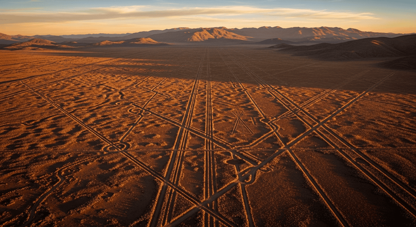
The Sajama Lines: Bolivia's Forgotten Geoglyphs That Dwarf Nazca
A Network Hidden in Plain Sight
Deep in the Bolivian Altiplano, stretching across an area larger than many countries, lies one of archaeology's most overlooked mysteries. The Sajama Lines form a vast network of geoglyphs covering approximately 22,000 square kilometers – an area fifteen times larger than the famous Nazca Lines of Peru. Yet despite their immense scale, these ancient pathways remain largely unknown to the world.
Located near Sajama National Park in western Bolivia, this intricate web of perfectly straight lines was created by indigenous peoples between 500-1400 CE. The lines, known locally as ch'ila, extend in all directions across the harsh volcanic landscape, with individual traces stretching up to 20 kilometers in length. The total network spans an estimated 16,000 kilometers – enough to stretch from New York to Sydney.
Engineering Marvels of the Ancient World
The construction of these lines represents a remarkable feat of ancient engineering. Created by carefully removing dark volcanic rocks to reveal lighter soil beneath, each line maintains extraordinary straightness across vast distances. Unlike the Nazca Lines, which are best viewed from above, the Sajama Lines follow the natural topography, crossing mountains, valleys, and plains with unwavering precision.
Archaeological surveys have identified several distinct types of lines. Radial patterns emanate from ancient settlements and ceremonial sites, while parallel lines run for dozens of kilometers across the plateau. Some researchers, including archaeologist Antti Korpisaari from the University of Helsinki, suggest the lines may have served multiple functions – as pilgrimage routes, astronomical alignments, or territorial markers.
The scale of the project is staggering. Conservative estimates suggest that creating this network would have required decades of coordinated labor involving thousands of people. The precision required to maintain straight lines over such distances indicates sophisticated surveying techniques that challenge our understanding of pre-Columbian capabilities.
Theories and Sacred Purposes
Several compelling theories attempt to explain the Sajama Lines' purpose. The astronomical hypothesis proposes that certain lines align with celestial events, particularly the winter and summer solstices. Local Aymara traditions speak of the lines as takanas – sacred pathways connecting communities to mountain spirits and ancestral realms.
Dr. Maria Ines Velasco, a Bolivian archaeologist, suggests the lines formed part of a complex ritual landscape where different communities maintained specific routes for religious ceremonies. This theory gains support from the discovery of small shrines and offering sites along many lines.
The trade route hypothesis proposes that these paths facilitated movement across the challenging Altiplano terrain, connecting distant communities and resource areas. However, the lines' extreme straightness – often ignoring easier topographical routes – challenges this purely practical explanation.
A Mystery Awaiting Recognition
Despite their archaeological significance, the Sajama Lines face threats from modern development and lack the protection afforded to Nazca. Climate change and increased tourism pressure the fragile ecosystem, while mining activities encroach on this irreplaceable heritage.
The Sajama Lines represent one of humanity's most ambitious ancient projects, yet they remain largely unstudied compared to their Peruvian counterparts. As researchers continue investigating this remarkable landscape, each discovery adds new pieces to the puzzle of Andean civilization.
[!] Various theories exist. Information may contain errors.